

Biotech Frontier:
Quantum EDGE Blogs
Biotech Frontier:
Quantum
EDGE Blogs
Exploring the Cutting-Edge of Biotech and Innovation
Technology and biology are converging like never before, unlocking new possibilities for enhancing human potential. Biotech Frontier serves as your gateway to the latest discoveries and innovations shaping the future of health, consciousness, and longevity.
The Drone Revolution: Harness Futuristic Business Opportunities for Ecosystem Restoration
📝Table Of Contents:
Seeing the Unseen: Mapping Ecosystem Challenges
Step 0 — Pre-flight: clarify the hypothesis & partners (Day −14 to 0)
Step 1 — Site survey & baseline mapping (Day 1–3)
Step 2 — Design the intervention (Day 3–7)
Step 3 — Regulatory & safety clearance (Day 4–10 — parallel)
Step 4 — Tech check & mission rehearsal (Day 7–10)
👉Use drones for good—become a conscious change agent
Step 5 — Execute the seeding sortie(s) (Day 11–21)
Step 6 — Automated monitoring cadence (Week 2 → Week 12)
Step 7 — Data processing & storytelling (Week 4 onwards)
Step 8 — Iterate, package & price (Week 8–12)
Step 9 — Scale & compliance (Month 4+)
Ethics, consent & community — restoration done well
Launch Sequence: Harness the Drone Revolution
Seeing the Unseen: Mapping Ecosystem Challenges
Drones are not a novelty anymore; they’re instruments of care. That change is both tactical and moral: tiny, cheap airframes can now do what used to require helicopters, boots on the ground, or month-long field surveys.
For anyone exploring futuristic business opportunities, ecological restoration is one of the clearest places where innovation, impact, and revenue meet. The question I carry is simple: how can we use flight to heal ecosystems reliably, ethically, and at scale — without replacing the people and knowledge that already steward the land?
Before we can restore a degraded landscape, we must understand it. Drones equipped with multispectral cameras and LiDAR can reveal:
Soil Health Variability (nutrient deficiencies, compaction)
Vegetation Gaps (areas of low canopy cover)
Water Flow Patterns (erosion risks, pooling)
🧠 Did You Know? A recent review in Methods in Ecology and Evolution highlights that UAV‑based mapping improves restoration planning accuracy by over 60 percent Tandfonline
Run a Drone Restoration Pilot
Goal: Validate a repeatable Restoration-as-a-Service workflow, measure outcomes, and prove unit economics for a scalable offering that taps into futuristic business opportunities.
Step 0 — Pre-flight: clarify the hypothesis & partners (Day −14 to 0)

Objective: Define a single, measurable hypothesis (e.g., “Drone seeding increases 90-day seedling survival by 25% vs manual broadcast”).
Actions:
Identify a willing landowner/manager and an ecological advisor (local Landcare, university, or extension officer).
Choose a 1–5 ha test patch and gather baseline permissions/land access consent.
Map the success criteria and KPIs (cost/ha, seedling survival @90d, # flights per ha, data product price).
Outputs: Signed pilot agreement, baseline map, KPI sheet, contact list.
Who: Founder / project lead, ecologist, landowner.
Step 1 — Site survey & baseline mapping (Day 1–3)

Objective: Create a high-quality baseline dataset to plan intervention and measure change.
Actions:
Fly an initial mapping mission: RGB + multispectral (NDVI) + altitude data. Use RTK/PPK if available for sub-meter alignment.
Walk the site with the ecologist to ground-truth the map (photo points, soil notes).
Produce orthomosaic, NDVI map, and a simple “issue map” (erosion, invasive patches, optimal seed zones).
Outputs: Geo-referenced baseline maps, annotated issue map, flight log
KPIs: Map coverage %; ground-truth concordance (photopoint samples)
Who: Drone operator (RPAS), ecologist, data person
Step 2 — Design the intervention (Day 3–7)

Objective: Turn the issue map into a seed-and-care plan that fits the drone payload & flight plan.
Actions:
Choose species mix with the ecologist (native, resilient to local conditions).
Define seed density, pellet size, clustering patterns to maximize water capture and genetic mix.
Validate payload weight and dispenser characteristics with your airframe vendor.
Outputs: Mission plan (GIS polygon of seed zones), seed bill of materials, seed logistics plan
KPIs: Seed mix chosen; payload compatibility confirmed
Who: Ecologist, product designer, drone tech
Step 3 — Regulatory & safety clearance (Day 4–10 — parallel)

Objective: Secure legal permissions and minimize risk. Don’t skip this.
Actions:
Check local UAV/BVLOS rules, protected-area restrictions, and wildlife nesting seasons. File waivers if needed.
Notify local authorities and land managers; publish a public-notice if required.
Prepare a Safety Management Plan (SOPs, emergency procedures, crew roles). Ensure insurance covers operations.
Outputs: Permits, SLP (safety/launch plan), insurance confirmation, stakeholder notifications
KPIs: Permits obtained, safety sign-off
Who: Legal/compliance lead, operations lead
Step 4 — Tech check & mission rehearsal (Day 7–10)

Objective: Make the mission predictable. Test everything on a rehearsal patch.
Actions:
Dry-run dispenser firing with inert pellets on a small control plot. Log accuracy and GPS offsets.
Test RTK/PPK alignment, return-to-home behaviors, and battery endurance at planned flight altitudes.
Confirm on-board data capture (images, telemetry) and the data pipeline (upload + processing).
Outputs: Rehearsal report, dispenser calibration table, data pipeline tested
KPIs: Drop accuracy (meters), flight time consistency, no failed telemetry >0%
Who: Drone tech, data ops
👉Use drones for good—become a conscious change agent
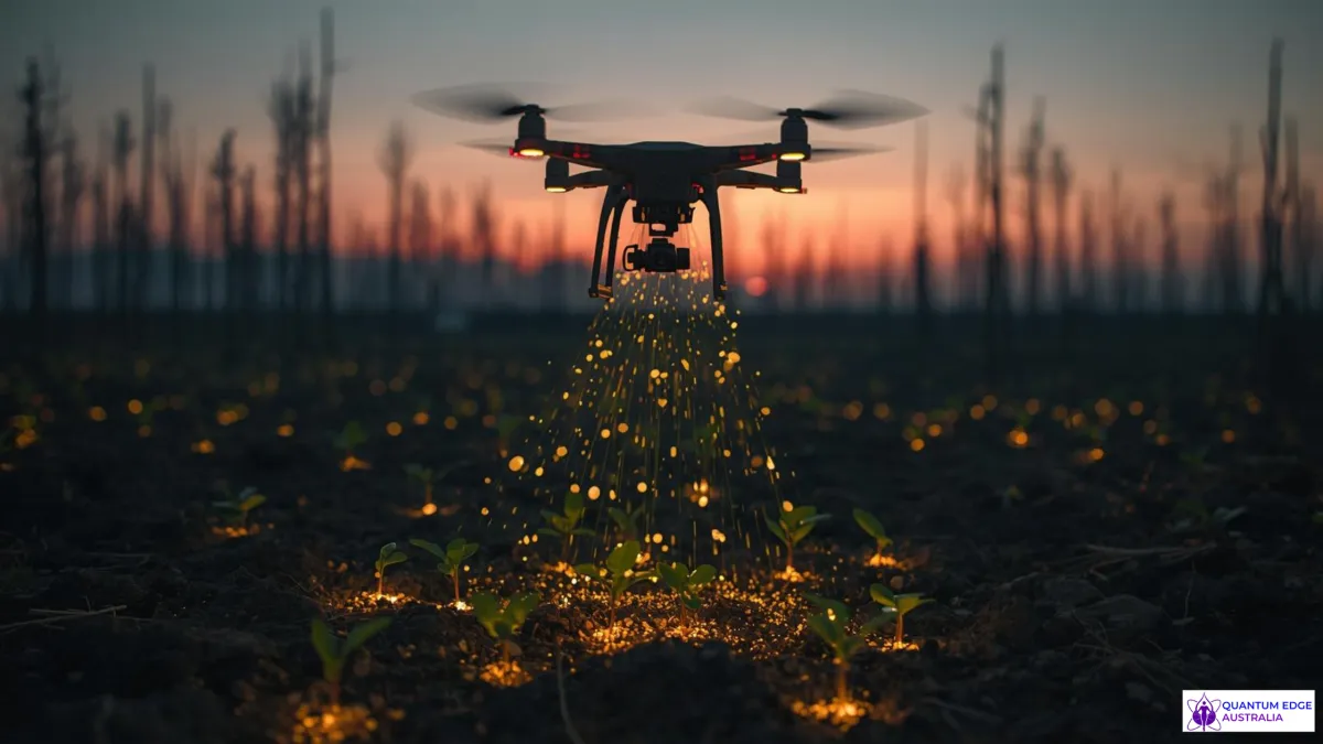
Step 5 — Execute the seeding sortie(s) (Day 11–21)

Objective: Deliver the intervention with rigorous logging for repeatability.
Actions:
Fly planned sorties, keeping tight mission logs: seed counts, GPS coords per drop, wind conditions, altitude and airspeed.
Use staggered seeding patterns across subplots to enable A/B comparisons later.
Collect on-site photos and short video for storytelling.
Outputs: Mission logs, before/after imagery, sample seed-count verifications
KPIs: Seeds deployed per hectare, nominal vs actual payload dispensed, flight completion rate
Who: RPAS pilot, field tech, project lead
Step 6 — Automated monitoring cadence (Week 2 → Week 12)

Objective: Track emergence, survival, and early stress signals with repeat flights and ground checks.
Actions:
Schedule weekly (or biweekly) repeat flights with the same sensors + fixed photopoints. Use automated change-detection scripts to flag low survival areas.
Field teams perform targeted visits to failed patches for corrective actions (re-seed, soil amendments).
Log maintenance and manual fixes as part of the operational cost ledger.
Outputs: Time-series NDVI, seedling counts, survival percentage reports, maintenance log
KPIs: Seedling survival @30d, @90d; % area needing manual rework; cost/ha to reach survival threshold
Who: Data ops, field crew, ecologist
Step 7 — Data processing & storytelling (Week 4 onwards)

Objective: Turn raw images into products you can sell and narratives that attract the next pilot.
Actions:
Stitch orthomosaics, compute NDVI/vegetation indices, and run automated seedling detection models (or manual annotation for small pilots).
Build a simple dashboard: baseline map, latest map, 90-day survival chart, cost-per-ha.
Create a short case video and a one-pager for potential customers and funders.
Outputs: Dashboard link, case video, one-pager with KPIs
KPIs: Dashboard load time, number of stakeholders engaged, demo requests
Who: Data person, storyteller/marketing
Step 8 — Iterate, package & price (Week 8–12)

Objective: Turn learnings into an offer and pilot the pricing model.
Actions:
Review metrics: cost per hectare, survival rates, labor hours, equipment wear. Identify process bottlenecks.
Adjust seed density, flight patterns, or post-plant maintenance to improve survival or cut cost.
Build a pricing model (RaaS subscription, performance contract, DaaS map product) and test with early adopter landowners.
Outputs: Updated SOP, pricing sheet, 2-page service offering
KPIs: Target margin %, repeat contract interest %, CAC (cost to acquire pilot customer)
Who: Founder, product ops, sales
Step 9 — Scale & compliance (Month 4+)

Objective: Move from one pilot to repeatable multi-site deployments.
Actions:
Standardize deployable kits (airframe + payload + instructions + data pipeline) and recruit/ train local ops partners.
Build a QA program and certification checklist for partner teams.
Ensure all data governance, insurance, and regulatory filings scale with geography.
Outputs: Partner onboarding kit, QA checklist, operations playbook
KPIs: Time-to-deploy per site, cost-per-ha reduction, partner NPS
Who: Ops manager, partnerships lead, legal
Ethics, consent & community — restoration done well
Restoration projects are rarely neutral political acts: they touch livelihoods, cultural sites, and local land rights. Meaningful practice includes:
Community co-design: involve local stewards in site choices, species selection and monitoring priorities. Offer training & shared ownership of data.
Transparency: publish flight logs, species lists, and simple survival reporting so communities and funders can see progress.
Minimize harm: avoid disturbing nesting seasons, use low-noise flight patterns near people, and choose non-invasive interventions.
Data governance: store imagery responsibly, anonymize any personally identifiable information, and get explicit consent for mapping private land.
These practices create defensible programs that scale with trust.
Common pitfalls
Treating drones like magic instead of systems. Drones are part of a human + machine workflow — if ground logistics and local maintenance aren’t solved, the drone becomes a shiny failure
Ignoring regulatory realities. BVLOS, permissions near protected areas, and wildlife disturbance rules differ by jurisdiction. Always plan for legal overhead.
Over-engineering the hardware. Start with off-the-shelf sensors and a simple dispenser; iterate on the payload only after process metrics are steady.
Underestimating data ops. You’ll generate huge files fast — processing, labeling and delivering clean maps is where most teams get bogged down.
Failing to co-design with local communities. If planting patterns ignore local harvesting, cultural sites, or grazing cycles, you create conflict, not restoration.
🔗Looking to turn insight into implementation? Our Quantum Edge Toolkits & Workshops are designed for hands-on innovators ready to build, test, and launch future-ready ideas with clarity.
🛠️ Explore Our Toolkits & Workshops
Launch Sequence: Harness the Drone Revolution
Drones are more than flying cameras—they’re precision tools for futuristic earth solutions and new business models in sustainability. By mastering mapping, targeted seeding, monitoring, and community innovation, you can heal ecosystems on Earth—and prototype eco‑tech for the cosmos.
Technology will give us new levers. But restoration asks a different kind of measurement: resilience, not just yield.
💭If you could guarantee one measurable improvement for the place you care about (soil organic matter, seedling survival, pollinator visits), what would you commit to prove within one year — and who would you partner with to make that promise credible?
👉Use drones for good—become a conscious change agent

📖Resource & Tool links:
Dendra / ecosystem restoration case study (example of large-scale drone restoration work)
AirSeed / reporting on drone reforestation in Australia (news + example of seedball approaches)
Monograph / stakeholder perceptions study (Monash–Warwick / Dronelife summary)
Technical primer: PPK vs RTK drone surveying (Propeller Aero)
MicaSense (multispectral sensors)

Join the Movement
At Quantum Edge Australia, we believe that knowledge fuels transformation. Whether you’re an entrepreneur, a starseed, or a visionary seeking clarity, this space is dedicated to supporting your journey.
Stay updated by subscribing to our newsletter:

CONTACT US
Email Address: [email protected]
Telephone Number: 0487 685 116
Address: 49 Inverness Drive Perth WA 6210
©Quantum Edge Australia 2025 All Rights Reserved
Facebook
Instagram